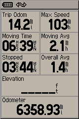
I’m recovering well from yesterday’s hike to Sid’s Mountain. I’m really not all that sore, and certainly not as sore as I was after my lame 8.6 mile hike a month ago. I’ve uploaded a lot of pictures here. Eight people in all were along for the hike. We began the hike at 7:30 in the morning and didn’t arrive back at the trailhead until about 6:00 pm. Round trip was 14.2 miles, which is by far the longest hike I’ve ever done. Here is my GPS trip data:

Not only was this the longest hike I’ve been on, but it was also the most remote area I’ve ever been in. Despite that, there was an old cowboy cabin up on top that was built in the 1940s that was quite interesting, and lots of other signs of modern human use. Not as obvious, but still noticeable if you look closely, are a lot of signs of Fremont Indian use from more than 1,000 years ago.
We began the hike by snaking our way down a steep hillside into North Salt Wash. The water in the bottom was frozen, but shallow enough that when it was flowing on our way back in the evening, it would still be crossable without getting wet. After crossing the bottom of the wash, we hiked up a half-mile long ridge that gained about 600 feet in elevation over its length. It was a much gentler slope than we’d descended on the other side of the canyon, but it was our first taste of exertion for the morning. After reaching the top of the ridge, we were on the plateau which is called Sid’s Mountain. It’s not really a mountain at all, but a large, flat plateau that’s surrounded by deep canyons on all sides.
From that point at the top of the ridge, we hiked another 3/4-mile on relatively flat ground until we reached a well-worn horse trail. We followed the horse trail most of the rest of the day. We went to the old cabin and found the geocache there, then pressed on and hiked up a 250-foot high sandstone knoll to another geocache. Inside the geocache somebody had left the coordinates to some petroglyphs, so we took a detour to look at them.
On our way back to the trailhead, instead of hiking down the ridge we’d come up, we followed the horse trail back down into North Salt Wash. A few people who still had some energy left (myself not included) split off from the group and visited some more petroglyphs in canyon bottom, but we all met up again near the bottom of the steep climb back up to our vehicles. We got back to the top just as the sun was setting, and it had fully set before we finished our goodbyes and drove away. As we were bumping along the dirt road back to civilization, the full moon was rising in the east.
I was beat by the time I got home, and I started feeling sick a couple of hours after that. I’m not sure if it was from exhaustion or something else, but today I’m feeling great. I’m already scheming to make another trip to Sid’s Mountain, probably an overnighter later this year after it warms up a bit more. There’s a lot up there to explore, and relatively few people have or ever will go there.