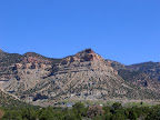
 I did something today that I’ve wanted to do for years. The difficulty of it has always put me off, but for some reason last night I made the decision to just go for it and hike to the top of the mountain just north of Kenilworth. When I was a kid living in Kenilworth, I once hiked up the old tram grade, but never made it farther than that. The tram grade goes more than halfway up the mountain, but it’s relatively easy to hike up. Once you reach the top of the tram grade, the terrain is steep and loose, with lots of rocks, boulders, and fallen trees. Another reason I kept putting this hike off is because it had always been either too hot or too cold when the urge struck me, but today I just didn’t care. It almost got up to 90° today, I got pretty sunburned and had to carry a lot of water with me, but it was worth it.
I didn’t leave home until pretty late in the morning today, and I parked the car just below the water tank above Kenilworth. The tram grade had been torn up during the mine reclamation a few decades ago, but it was still a fairly easy hike up that part. I stopped several times to drink some water and let the burning in my legs subside a little. Torrey spent the whole hike up chasing after grasshoppers and lizards, and she showed a lot of interest in a dead deer about halfway up the tram grade. The higher we climbed, the more remnants of the tram there were–rails, ties, cables, pipes, etc. At the top of the tram grade, there was a wide, sagebrush-covered area with a cliff dropping down one side and another cliff rising up on the other side. This was the part I was most worried about, because I didn’t know whether I’d be able to get past the cliff going farther up the mountain. I had to spend a few minutes standing at the bottom of the cliff looking for a way up, but I eventually spotted a way up that was pretty easy.
After that, the going got tough. The trees were thick and the hillside was steep, and it was difficult picking my way up the mountain. It was only about 700 horizontal feet from the top of the tram grade to the top of the mountain, with an elevation gain of about 400 feet, but it took me about 30 minutes to cover that much ground. Once I reached the top, the view was amazing. I could see the Book Cliffs stretching south all the way to Mt. Elliott, and I could see the Wasatch Plateau well into Emery County as well. Even the uplift of the San Rafael Swell was clearly visible from there. I placed a geocache near the top, called my wife to let her know I had made it, then started the descent down.
What had taken me three hours to hike up only took 30 minutes to hike down. My round-trip hike was only 1.75 miles, and according to my GPS I spent about 1/3 of the entire time stopped to rest. I’m kind of bummed that I didn’t get a chance to hike across the shelf line to see the actual mine, but the shelf line has crumbled and fallen down the mountain, and the way across looked to steep to hike across, especially without someone else there to help me in case I got into trouble. I may go back someday just to see the mine, but at least for now I can check one thing off my List Of Things To Do Before I Die. 🙂
That’s cool you went up there. I have always wanted to hike over the entire mountain to the other side, but I was a kid then. Maybe before i die I will hike my lazy but up there. Kenilworth is an amazing town I will always remember the people, and the sights as vividly as when I was little.
I have always been fascinated by Kenilworth and the old mining operations there. I remember finding a website a while back that had pictures from way back when. Sounds like you have a great hike in a great area.