Price Canyon Recreation Area to Ford Ridge

Yesterday morning I made last-minute plans to hike from Price Canyon Recreation Area (referred to as simply “Price Rec” by many locals) to Ford Ridge. The hike has been languishing on my to-do list for years, and when I woke up it just seemed like a good, close-to-home, strenuous hike was what I needed. The lower portion of the trail leads to an overlook of Crandall Canyon. Before reaching the overlook there’s not much of a view, but beyond the canyon rim the trail follows a ridge and there are great views in all directions. I’ve hiked the lower trail many times with my family but had never gone beyond the Crandall Canyon overlook. On the ridge there are bristlecone pine trees and brief views of the highway in Price Canyon.

Start of the trail at Price Canyon Recreation Area


15 minutes up the trail, first view of peak 9,519′
15 minutes up the trail, first view of peak 9,519'


Dead ponderosa pines


Bristlecone pines growing in the boulders


On the ridge, approaching peak 8,510′
On the ridge, approaching peak 8,510'


Highway 6 and railroad in Price Canyon


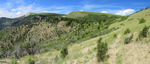
The elevation gain is pretty gradual except for the ascent to the two larger peaks on the ridge. In one of the saddles before reaching peak 9,001′ was a log that had been hollowed out with an axe to create a trough. I followed a faint ATV trail beyond the saddle to the base of peak 9,001′, atop which was a small cairn. In the saddle just beyond the peak I spotted a bear track that thankfully wasn’t fresh. That makes three times in a row that I’ve been in the vicinity of Ford Ridge and seen tracks, scat, or an actual bear.

Peaks 9,519′ (left) and 9,001′ (center)
Peaks 9,519' (left) and 9,001' (center)


Sego lily (Calochortus nuttallii)


View over Price Canyon to the distant Book Cliffs


Log hollowed out into a trough


View east from just below peak 9,001′
View east from just below peak 9,001'


Peak 9,001′
Peak 9,001'


Cairn on top of peak 9,001′
Cairn on top of peak 9,001'


Radio towers
Radio towers


Peak 9,519′
Peak 9,519'


Views of Spring Glen, Price, and Wellington


Peak 9,519′
Peak 9,519'


Old bear track
Old bear track


During the steady ascent the rest of the way to peak 9,519′ I saw gnarled bristlecone pines, deer, another log-trough, and a curious prairie dog. At the top of the peak I found the 1910 survey marker and only briefly enjoyed the views before heading back down the way I’d come. On the descent I noticed an axe carving on a tree from 1940 that I hadn’t spotted on the way up. Climbing back up peak 9,001′ wasn’t as painful as I’d expected–it was the only major uphill portion on the way back to the recreation area. It had taken me almost four hours to ascend and well under two hours to descend.

Bristlecone pine
Bristlecone pine


Two handsome bucks in velvet


Retreating bucks
Retreating bucks


Another hollowed out log trough


Ascending to peak 9,519′
Ascending to peak 9,519'


Bristlecone pine
Bristlecone pine


Prairie dog
Prairie dog


Crandall Canyon
Crandall Canyon


Chiseled triangle survey marker from 1910 on peak 9,519′
Chiseled triangle survey marker from 1910 on peak 9,519'


View back along my route


Doe checking me out
Doe checking me out


L.D. 1940 carved with an axe into a tree


Horned lizard
Horned lizard


The Jeep below
The Jeep below


Cottontail rabbit
Cottontail rabbit


GPS back at the trailhead


Photo Gallery: Price Canyon Recreation Area to Ford Ridge
GPS Track and Photo Waypoints:
[Google Earth KMZ] [Gmap4 Satellite] [Gmap4 Topo]
Leave a Reply

Your email address will not be published.