
 I wanted to get away for a quick overnighter this past weekend, but nothing in the San Rafael Swell interested me. I had read Scott P’s trip report from the previous weekend in Crescent Creek on the east side of the Henry Mountains. I started poking around that area in Google Earth and decided it would make for a great quickie in an area to which I’d never been. I hastily made a plan to spend Friday evening checking out Little Egypt and some Morrison Formation hills south of there, then camp at Pysert’s Hole that night. On Saturday I’d planned to hike in Pysert’s Hole, then drive north to Copper Creek and hike there, then drive north again to hike around Crescent Creek, and finally, if I had time, drive south on UT-95 and hike up Leprechaun Canyon. Not being familiar with the area, I wasn’t sure how feasible the plan was, but I was open to changing plans on-the-fly if something didn’t work out.
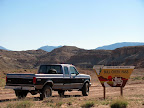
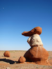 I left home right after work on Friday at around 3:00 PM, stopped in Hanksville to top off the fuel and grab a drink, and was at the turn off of UT-95 after about two hours on the road. Little Egypt was only a short distance down the road, and there was a sign and parking area right where the rock formations begin to get interesting. I walked around the area for a little more than an hour. The formations are similar to those in Goblin Valley, made of Entrada Sandstone, but Little Egypt has some white layers that starkly contrast with the dark reddish-brown. From Little Egypt, I drove south several miles to some Morrison Formation hills which I’d first seen many years ago when the first color satellite imagery became available on the internet. From the air, the hills looked amazing, with alternating layers of purple and white eroded into strange patterns. In person, it wasn’t quite as spectacular. The low sun made for some nice lighting, though, and I had a fun time scrambling to the top of one of the hills and enjoying the view from there.
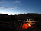 I backtracked a little down the road and accidentally passed the turnoff to Pysert’s Hole. Once I reached North Wash I realized my error and turned around, but the sun had set behind the tall Henry Mountains. As I approached the narrow entrance to Pysert’s Hole, the road abruptly ended more than a mile short of where I’d wanted to camp. The wash had apparently undercut the road and left a bouldery dropoff where the road once followed the edge of the wash. The light was already dimmer than I was hoping to set up camp in. There was a barely-wide-enough spot to get the truck off the road and a perfectly-sized sandy spot in which to set up the tent. I set up camp, ate a quick, cold dinner straight from a can, and sat in my camp chair and read a book by the light from my headlamp. I went to bed around 11:00 PM, but it was hot and I couldn’t get to sleep. The wind picked up and there some really violent gusts. Once I had to crawl out of the sleeping bag to pound in the stake that held the vestibule door down, since the wind had ripped it out of the ground. The wind calmed down suddenly after 1:00 AM and there was a light sprinkle for about 10 minutes, then things were nice and cool and calm after that. Some distant coyotes began to howl then, however–or perhaps only then could I hear them without the wind–but they kept me awake for a while longer. I finally got a few solid hours of sleep, but I awoke at about 5:30AM and slept fitfully for a couple more hours before I got up. It was getting hot by then, and outside the bugs were the worst I have ever experienced! If I stood still for more than about five seconds, there would literally be several dozens of small flying insects in and around my ears, eyes, nose, and mouth. I almost pulled up the tent stakes and threw the entire thing, with gear inside, into the truck bed and booked it out of there. I toughed it out and made some coffee, picked the bugs out, and drank it inside the truck where the bugs weren’t swarming as badly. I took down camp properly and stowed all the gear in the truck, then took off.
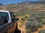 Since I couldn’t get into Pysert’s Hole proper, and it was already hot enough that I didn’t want to hike the extra couple of miles to get there, I headed north with the intention of hiking up Copper Creek. The area where the road appeared to end in Google Earth looked absolutely perfect for hiking. Beyond the road’s end, the creek cuts deeply through some sandstone, and there are several forks to explore. On the way there I stopped near a corral to look at a burned trailer and nearby outhouse. Unfortunately, more than a mile before the road appeared to end in Google Earth, the road petered out into a series of washouts and relatively thick sagebrush. It didn’t look like a vehicle had been through there in years, and my truck certainly wasn’t suited for that kind of “road.” Again I didn’t want to add a couple of uninteresting miles to the hike, so I turned around and headed for Crescent Creek.
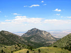 Crescent Creek was pretty interesting, and I’m sure I only saw a small fraction of the cool stuff there. I saw a few old cabins near the road, some mine workings and adits, and some old wooden bridges across the narrows. I hiked a short distance up the bottom of the Crescent Creek narrows, but I turned around when it got so narrow that to proceed further I would have needed to walk in the creek. I was wishing I’d brought some old shoes so as to not ruin my newish hiking shoes in the water. I hiked around Lecleed Spring as well, which is at the top end of the narrows. Since I had so much time remaining due to not hiking in Pysert’s Hole or Copper Creek, I decided to give Bull Creek Pass a try. I’d been told by Randy that there would still be snow drifts remaining on the road in the higher elevations, but it still sounded fun to try. I climbed west higher into the Henry Mountains. The road climbed steeply and contoured around the ridges, and I was in 4-low most of the time just to keep the strain on the engine low. I made it to within 0.65 miles as the crow flies (or just over one road mile) of Bull Creek Pass before hitting a snow drift that covered most of the road surface. I might have made it through with a little digging, but the next north-facing slope that the road traversed looked even worse. I backed a couple hundred yards down the hill before reaching a spot wide enough to turn around, and it still took a 10-point turn to get facing the opposite direction.
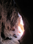 After about an hour of driving down off the mountain, I found myself at the bottom Leprechaun Canyon. I went from being on a snow-covered mountain road to a hot, sandy, slickrock canyon in such a short time–one of the reasons I love Utah so much. Leprechaun Canyon is normally a technical route done from the top-down, but from the bottom one can still hike up the canyon for about a mile. The first two-thirds of the hike was hot and relatively uninteresting. The remaining part was quite amazing, however. There’s a long “subway” section where the bottom of the canyon is wide but the top narrows to a small slit, so very little sunlight reaches the bottom. It was cool and shady there, and I ran into a group of canyoneers on their way down the canyon, several of whom stopped to introduce themselves to Torrey. I didn’t quite make it to the end of the hiking route because, again, I wasn’t equipped with the proper footwear. I tried stemming over a a big muddy puddle, but the sides of the canyon were slippery with mud and one foot slipped and was submerged in the water. I retreated, not wanting to hike back to the truck in mud-filled shoes. I believe I was only a hundred feet or so short of the dryfall where my hike would normally have ended, but it was so dark inside the canyon that I couldn’t even see that far. I hiked out and caught up with the canyoneers, who I followed uncomfortably close to for about half a mile–they were hiking a lot slower than I was, but there wasn’t room to pass the group. Back at the truck, I pulled out a Powerade that I’d stashed in my 5-gallon cooler of ice water, and enjoyed a very cold drink on the drive home.
 I think the next time I go to the Henry Mountains area, I’ll do it in the fall when temperatures are cooler but the snow is gone, and I’ll definitely bring the ATV. There’s a dearth of information about the area, which seems strange considering how awesome it looks to be. Even the BLM’s route map is severely lacking in detail, which makes planning difficult. I know I’ll have more time to plan another trip, and hopefully I can piece something together that works out better than this trip. This was still a very fun trip, so I can only imagine what I can come up with next time.
Photo Gallery
GPS Tracklog and Photo Waypoints (Google Earth .KMZ Format)
GPS Tracklog and Photo Waypoints (Google Maps)
Pingback: Udink.org − Mount Ellen