I had a pretty crappy day Saturday, so yesterday I went for a hike with Mark to the Aberdeen mine near Kenilworth. I’ve wanted to hike to the mine for many years, but just never took the opportunity to do so until now. The USGS topo map shows the Aberdeen mine in a side-canyon off of Cordingly Canyon, and that canyon basically runs between and parallel to Cordingly Canyon and Bull Hollow. However, most of the information I’ve found on the web relating to any “Aberdeen mine” near Kenilworth seems to refer to another mine (or several mine openings) either in Bull Hollow or on the mountain just above Kenilworth. In addition, there’s another Aberdeen mine several miles away near Coal Creek, so it’s been difficult finding specifics about the mine I visited. The best information I’ve found that clearly refers to the mine we hiked to is in a 1972 publication by the Utah Geological and Mineralogical Survey. That publication gives UTM coordinates that closely match up with the position shown on the topo map. It says that this particular Aberdeen mine was in operation from 1898 to 1916, but gives little else.
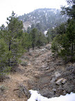
When I called Mark to see if he wanted to go with me, it was sunny outside and the breeze was pretty calm. An hour later when I picked him up on my way to Kenilworth, it was extremely windy and the sky was filled with so much dust that it was a gray-white instead of blue. There still weren’t a lot of clouds around, but the sun was pretty much blocked out. We parked along the side of the gravel road in Cordingly Canyon and hiked up the unnamed side-canyon toward the mine. The hike was fairly easy, with some light bushwhacking in places and a little bit of scrambling over boulders and such.
 There’s an old wagon road that winds in and out of the bottom of the canyon, though it’s almost completely obliterated in places. Due to the steepness of the wash, I’m sure there had to have been small bridges where the road crossed it, but there were no signs of them now. The road has been in a state of disuse for so long that it’s been reclaimed by nature to the point where it’s no longer recognizable as a road. In places there are 20-foot tall trees growing in the middle of it. Near the mouth of the canyon we found an old miner’s camp complete with a mattress spring (all the fabric and stuffing has long since rotted away) and the remains of a crude shelter. We also encountered an old wooden gate about halfway between the mouth of the canyon and the mine, which was presumably used to keep people from loading up their own wagons with coal.
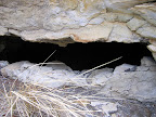
 Shortly before reaching the mine we ran into an area that was completely covered in coal, which I assume is where they loaded the wagons to ship the coal out of the canyon. Just beyond that was the mine itself, though the entrance was long ago filled in with dirt and rocks. There are still some timbers that probably made up the headframe and shoring, but they’re mostly buried. A couple hundred feet up the canyon from the mine we found another opening that had been sealed off with rocks and mortar and then partially buried, but it looks like somebody had pulled out enough rocks from the wall to squeeze inside. I couldn’t see much inside, but I stuck my camera through the opening and took a few photos with the flash on. There had to have been a deeper mine shaft behind the rock wall, but it must have collapsed because there’s only a small room there now. There was also a strong odor coming from the opening, sort of like lighter fluid or diesel fuel. Methane is supposed to be odorless, so I’m not sure what would have caused that smell.
After seeing what little there was to see near the two mines, we started the hike back down the canyon. On our way back to the truck, we climbed out of the bottom of the canyon and up onto a portion of the old wagon road that we’d skipped before. It pretty much followed the contours of the hillside, and in several places where it crossed small drainages there were the remains of old wooden bridges. It had been snowing lightly for most of the hike, and although it was windy, we were pretty sheltered from it in the bottom of the canyon. Up on the wagon road, however, it got really gusty, and there was enough shade there that there was a foot or more of lingering snow in a few places.
If it hadn’t been for the cold wind, I would have spent more time exploring the area near the mine. I had brought a geocache and intended to place it up there, but I forgot about it amid thoughts of hurrying up so I could get back to the truck. 🙂 I’ll probably go back this summer, since it’s such a short hike (a little more than two miles round trip), to poke around a bit more and maybe hike to the end of the canyon.