I was pleasantly surprised this weekend to find that there’s a lot more to do at the Wedge than I had expected. Traci, the kids, and I arrived at campsite #8 near the Wedge Overlook on Thursday evening, and we spent the rest of the day setting up camp, eating dinner, and relaxing around the campfire. We all had (and still have) colds and weren’t feeling great, so we turned in pretty early that evening.
We spent the next morning exploring the area around our campsite. The camp trailer was parked about 20 feet from the edge of a canyon that joined up with Good Water Canyon, and we all walked along the canyon rim after breakfast in order to scope it out, since we planned on hiking through the bottom of the canyon later when a few other people arrived. My sister Samantha and some of her kids showed up before noon, and it was nice to have some company. I got a little restless and went for a short drive on a bumpy and winding road that eventually linked up with the main road to the Wedge Overlook, and later I hiked even farther along the canyon rim near our camp. I hiked all the way to Good Water Canyon and back, but there were some parts of the side canyon that were too steep for me to see the bottom, so I still didn’t know what we’d be getting into when we eventually hiked down into it.
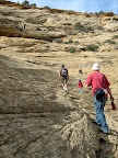
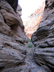
 Our friend Chris showed up that afternoon, and shortly afterwards everybody began the hike along the bottom of the canyon that we were camped near. The very top of the canyon cuts through the rough and block-like Carmel formation, but very shortly after beginning our descent we encountered the top of the Navajo sandstone layer and the canyon bottom smoothed out considerably. For the first 0.4 miles the bottom of the canyon stayed pretty much the same, with a mix of smooth, bare sandstone and sand-filled sections with trees and other vegetation. After that the bottom of the canyon narrowed and a very short slot section started. We reached the top of a 10′ drop that we couldn’t downclimb, and Chris and I were pretty sure we could scramble up the left (north) side of the canyon, but the rest of the group stayed behind because it was too steep for the kids. We climbed pretty high out of the canyon and skipped about 400′ of the bottom that was a mix of narrow water-filled slot and thick bushes. Once we regained the bottom of the canyon we ran into another steep drop that ended at the bottom of Good Water Canyon. Chris and I worked our way around the drop along a very sketchy route that I was sure would be difficult to climb back out of. We finally got into the bottom of Good Water Canyon and started heading south down the bottom of that canyon. It wasn’t long before we got to a huge dropoff (easily over 100′) that ended our progress down the canyon. I placed a geocache there at the edge of the drop but to the far left of the canyon to avoid it being washed away during flash flooding. We worked our way back to the north in Good Water Canyon to see if progress was possible going up the canyon, but we soon found another two dropoffs that were impossible to climb up, so we reversed our original route coming into the canyon and tried meeting up with the rest of the group. After we made it back past the most difficult part, I was surprised when my cell phone rang. It was just Traci, calling to let me know that they’d given up on waiting for us and had headed back to camp. Chris and I made it back to the easy part of the canyon and made good time back up the canyon. Samantha and the kids had only come down to spend the day, so they left before dinner time. Chris set up his tent, we all ate dinner and bull-shitted around the campfire the rest of the evening, then went to bed relatively early again.
 Sam and Mark were planning on coming down Saturday evening for a few hours, so my family and Chris went for another hike that day before they arrived. We drove down the road to the eastern part of the Wedge and then hiked to my geocache at the southeastern edge of Good Water Canyon. It was about a four mile hike for Chris and me, but Traci and the kids stopped about half a mile short of the cache and waited for us to get there and back. Twice we passed through one of my favorite areas in the Swell, a ponderosa pine stand in the bottom of a secluded canyon. I would like to have explored that area more, but Traci and the kids aren’t used to hiking that much and so we kind of slogged back to the truck. Sam and Mark arrived later in the evening and we had a good time at camp well into the night.
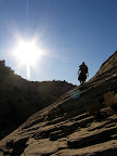
 Sunday was the day we were heading home, but we had to get one last hike in before we did so. We decided to check out the next canyon south of the one we had hiked on Friday. It started out much the same as the previous canyon, although we encountered some steeper sections in this canyon, one of which we had to bypass. After more than half a mile of pretty easy hiking, we got to a slot section that ended in another drop that was too steep to downclimb. Traci and the kids once again stayed behind while Chris and I looked for a way around the drop. We first went left along some ledges above the bottom of the canyon but we got cliffed out on that side. We returned to where Traci was waiting and then tried the right side of the canyon. We scrambled down yet another sketchy route going down below the drop, and we ended up in a narrow part of the canyon that had a flat bottom. After a short distance the flat bottom gave way to another short section of narrows that we stemmed over and downclimbed. At the end of the narrows the canyon opened up, and we were standing at the top of another huge drop. This canyon was very similar to the previous canyon we’d hiked, but it was longer and the narrows section was much better. I placed a geocache above this dropoff as well, then we reversed our route and were able to make it back to Traci and the kids without too much difficulty.
Chris headed home when we got done with the hike, but Traci and I still had a lot of things left to do in order to break down camp. We leisurely ate lunch, packed everything up and hitched on to the trailer, then drove home. I’m still wondering how I failed to notice all of these interesting canyons near the Wedge. After returning home and checking them out in Google Earth, I’m excited to go back this fall/winter for some more hiking.