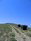
 Our ride along Ford Creek and up to Ford Ridge yesterday was well worth taking the day off work. In fact, I would really like to go back there another time or two to check out all the trails that we didn’t get to ride. We parked on the side of US-6 near the Ford Creek waterfall, then rode along the creek for the first two miles. After that, the trail crossed the creek and we began a long, steep ascent to the top of the ridge on the east side of the canyon. From there, the trail stays on top of the ridge all the way to Ford Ridge.
About six years ago I tried finding a USGS benchmark on the second-highest peak on Ford Ridge, but it was buried under hundreds of rocks and I didn’t have the patience to dig through them all. When we reached Ford Ridge yesterday that peak was the first place we went, and the benchmark had been uncovered and was plainly visible when we got to the top. I placed a geocache on the south end of the summit, where the views down into the valleys were awesome.
After leaving the peak and continuing south on the trail, we came to an intersection and followed another trail that went southeast along Ford Ridge. It was past lunchtime already, so we began looking for a shaded and level spot to eat lunch. We passed up a few mediocre spots at first, but soon we came to an area that was more heavily wooded and looked more promising. However, there was some bear crap in the middle of the trail near a place where I wanted to stop to eat, so we turned around and went back to a more wide-open place to eat our lunch. After eating, we rode farther southeast to the end of Ford Ridge. The trail actually went farther beyond that, but it was getting late and we knew that we still had a long ride back to the truck.
On our way back, we stopped at a place that I’d seen on the way up and had made a mental note to check it out. There were some birch trees that looked really out of place on an otherwise bare ridge, and it turned out that there was a natural spring there. The water was visibly gushing up out of the ground in a few places, and it ran through a wide marshy area down the hill into what used to be a cow pond. The downhill wall of the cow pond had been breached, so the water just flowed right through the bottom of it, then dropped in a rivulet down the steep mountainside below. I don’t think I’ve ever seen naturally-occurring birch trees in Utah, so I’m fairly certain that somebody planted them there. It was a nice peaceful spot, so I placed another geocache there since it was right next to the trail and a nice place to take a break from riding.
There are about five more trails in the area that I would like to ride, but next time we go there I’ll park farther up Price Canyon and take the main road into Ford Ridge. That road leads to several radio towers on the highest peak of the ridge, and it’ll be much faster for us to get to the area trails. Ford Creek is definitely worth riding at least once, but it’s not ideal as a primary means of accessing the other trails.