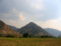
 Yesterday’s trip was great, but I only did about half of what I wanted to. I picked up Samantha and Mark at 8:30 in the morning and we hit the road on our way up toward East Carbon. I’d only been up as far as Water Canyon before, so the drive up to Bruin Point was all new to me. The road was steep and winding, but the view just got better as we climbed. Bruin Point was the highest part of the drive at about 10,100 feet, and you can normally see out into the San Rafael Swell from there, but with all the wildfires around here you couldn’t see nearly that far. The temperature was extremely pleasant, though it gradually got unbearable as we drove north along West Tavaputs Plateau and lost elevation.
Shortly after the landscape turned from pine and aspen to juniper and pinyon pine, we stopped at an old dirt landing strip and placed a geocache. After that point the road dropped 1,700′ over the next four miles, and we ended up in Cottonwood Canyon. The geology changed a lot there, from smooth plant covered hills to jagged and barren rock cliffs and spires. It was there that we again started seeing signs of civilization–big trucks hauling water and drilling equipment. Once we reached the first petroglyph panel, we started seeing more tourists as well, but there weren’t many. I’m sure the hot weather kept most of them away.
We stopped at the mouth of Daddy Canyon for lunch. The BLM has added vault toilets and a pavilion with picnic tables there. It was nice to sit in the shade while eating lunch, but the noisy compressor station and the heavy truck traffic along the road detracted from the beauty of the place. Nine Mile Canyon has changed a lot since I was last there five years ago.
Instead of returning home through Dry Canyon and back over Bruin Point, we stayed on the Nine Mile road and headed toward home–there wouldn’t have been enough daylight left to complete that part of the trip. We took a short detour into Gate Canyon, where I placed another geocache near a sandstone arch. The rest of the drive home was less interesting for me because I’d already been on that stretch of road a few times. We stopped to find a couple of geocaches, but other than that the ride home consisted of bouncing along the rough road and dodging semi trucks hauling equipment in the opposite direction or heading back to town empty.
The entire drive was about 113 miles and took 10 hours, and I burned a little over a half a tank of fuel in the truck. I’d really like to go back and try the Dry Canyon route. I’d imagine that it’s a lot like the Cottonwood Canyon route (since the two canyons run parallel through the same geology), only different.
Well i have drove the dry canyon route a few times and i have also drove the Cottonwood canyon before. And i can tell u that dry canyon is a lot different then Conttonwood. But still very beautiful. And yes there is water in the bottom of dry canyon.
I drove through Dry Canyon the week after I did Cottonwood Canyon, and it was indeed different, especially up higher. There was one place where it was really grassy, with some tall cottonwood trees providing a lot of shade–it was quite beautiful. It was July of this year, and it was weird, there was intermittent water in Dry Canyon. In some places there was a little bit of water flowing, and in other places there was no water, but later on we’d encounter another place where it was flowing, so it must go underground for short distances throughout parts of the canyon.
Ya it sure dose which is really weird i dont think i have ever seen another streem that dose that. And yes that is a beautiful i love going back there. I used to hunt deer back in there until they made most of it private. I would love to take a journy back behind that gates again but o well i guess.