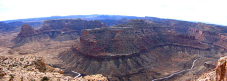
Luckily the weather held up for today’s hike, and it couldn’t have been more perfect. I really think winter is the best time for hiking the Swell. Mark and I left Price around 8:00am, and it probably took us well over an hour to reach the trailhead. We took the road leading to the Wedge overlook, but turned off a side road well before the overlook. That road eventually dead-ended, and that’s where we began our hike.

The hike involved a lot of route finding–luckily I brought a topo map with me, which I normally don’t do. I started out wanting to place a cache on the far southeastern tip of the Wedge, overlooking Buckhorn Wash, but I don’t think that’s possible without climbing gear. We came up about a mile short of our destination, but the hike there was pretty amazing.
There were two places along the route where you absolutely could not proceed further southeast without going past a specific point. One involved a mile-long sheer cliff that only had one place to descend onto the flat below, and another was a big hill where only one route over the top would take you to the other side. Every other way that we tried getting around these obstacles was a bust. That should make it a difficult cache to find, because I didn’t give out specific information on the cache page.
Round trip, the hike was 5.5 miles, which was surprising to me because we were never more than 1.5 miles from the truck. There was just a lot of zig-zagging and backtracking in order to get around obstacles. That country is very rough and remote, and it was great to do some exploring there. The Wedge is a big place to explore, but I’d like to do a lot more. The eastern half is where all the exciting stuff is, away from the touristy overlook. It looks like there’s some good trailer camping spots closer to the main road, and I’d like to camp nearby and do more playing around this spring.