Last week I had been debating whether or not to drive up to the Vernal area to do some hiking, geocaching, and sightseeing, and Thursday I finally made up my mind to do it. There is a geocache on Marsh Peak northwest of Vernal that was placed more than three years ago, but nobody had gone to find it, until Saturday. Since I was going to be in the area, I really wanted to visit Fantasy Canyon too. I figured it would take me the better part of two days, so I packed enough stuff for two nights.
I left home after work on Friday, and it took me 4.5 hours to get near where I’d planned on camping. I was actually about 1.7 miles short of my intended camping spot, but the road was really rough and daylight was fading quickly, so I pulled over at the nearest flat spot alongside the road. I fixed dinner which consisted of hotdogs roasted over a propane stove, potato chips, and iced tea. After eating, it was too dark to do anything useful. I took a few pictures of the full moon, then tried to go to sleep in the truck. I was too chickenshit to set up the tent–didn’t want to get mistaken for a meal by a hungry bear. I don’t think I slept continuously for more than 30 minutes at any time during the night, but after 8:00 sometime the next morning I felt rested enough to get my day started.
I ate a quick breakfast of a bagel and coffee, then packed everything back up in the truck and tried driving a little closer to the trailhead for Marsh Peak. I only got another 3/4 of a mile before pulling over and beginning to hike, since I could walk faster than I could drive on the rocky road. I parked at a fork in the road, but I ended up hiking down a different fork than I had told Traci I’d be taking, so I left a note on a wooden post saying which fork I’d taken.
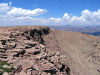
 The hike was mildly steep for the first mile and a half along what was mostly a 4WD road. At the next road junction, there was a trail sign for Marsh Peak, and the route turned into an ATV trail which continued for almost another mile before turning into a steep, rocky foot trail. The trail was well marked with cairns, and after it leveled out again it curved around the south side of Marsh Peak. I kept following the trail, thinking that it would eventually lead to the summit, but it appeared to keep going west. When I got directly south of the summit, I turned to the north and started the steep ascent.
Near the top, there are two buildings that used to house radio equipment, but they’ve been long abandoned and heavily vandalized. After checking the buildings out, I pressed on to the summit and reached it about three hours after starting the hike. The geocache was supposed to be under some rocks near the cairn at the summit, but since the entire mountain was nothing more than a big pile of rocks, I couldn’t find it easily. After looking for more than an hour, another hiker popped over the ridge to the east and was making his way toward me. When he got closer, he said, “You must be Dennis!” At first I was freaked out that he knew my name, until I remembered the note I had left near the truck. I talked to him for about 45 minutes, then he pressed on and I resumed my search. I finally spotted the cache, not really that far from where my GPS zeroed out, but hidden in such a way that you could only see it from a certain angle. I’d spent 2.5 hours looking for the thing, but seeing as how I’d come all that way just to find it, I didn’t want to give up easily.
After signing the log in the cache, I headed straight down the east side of the mountain. There was no trail, and it was much rockier than the southern slope, and I had to carry Torrey for about half the distance down to the main trail. I got back to the truck in an hour and 45 minutes, and hurriedly started making my way back down the rocky road. When I got to a place overlooking Vernal, I had spotty reception on my phone, but I called Traci to let her know I was coming down off the mountain. I told her I was planning on driving toward Fantasy Canyon, which is southeast of Vernal, but I didn’t think I could make it there before dark and I was probably going to camp somewhere along the way.
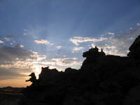
 To my surprise, the road to Fantasy Canyon was paved for all but the last few miles (I had expected more gravel and dirt roads), and I made really good time (I think just over three hours). I had enough time to eat a quick dinner of canned chili, and I still had 30 minutes before the sun went down. I hiked quickly around the area and took a lot of pictures of the rock formations and the setting sun. By the time it was dark, I had explored all of the area and had no other reason to stick around, so I decided to high-tail it home.
I called Traci from Vernal just before 10:00 pm and told her that I was on my way home. I didn’t pull into the driveway until after midnight, and I was too exhausted to even shower. I just brushed my teeth, hit the pillow, and slept for 10 hours straight.