I spent the better part of yesterday behind bars. Handlebars, that is. (See what I did there?) Our group of eight, led by Lyman, explored Boulder Mountain on dirt bikes. I’d previously hiked with all of the group members on different occasions, but this time it was a pleasure to spend some time with and learn from Lyman. Alan and I loaded our motorcycles into his van the previous evening and then left Price early the next morning and met up with some others at Wade’s house in Ferron. We staged near the Aquarius Guard Station at the base of Boulder Mountain where we met Lyman and Josh. We got rolling at about 9:45 and headed generally south until picking up a road that led east onto Boulder Top. There were a few interesting stops along the way, including one by me when I dropped my motorcycle while trying to climb out of a rut in the road. Luckily it was my only major mishap of the trip.
This trip was actually supposed to happen the previous weekend but the Forest Service hadn’t yet opened the gates onto Boulder Top due to snow drifts. The one-week delay made a big difference and we climbed up onto the plateau without encountering any snow on the road. We lunched at Spectacle Lake and then continued across Boulder Top on the way to Bown’s Point. One part of the road along the way crossed through Bakeskillet Lake. Wade braved through it first and then everyone followed. At the next major road junction we ran into a couple of vehicles, one of which was piloted by a good friend of Josh–another one of those “small world” moments.
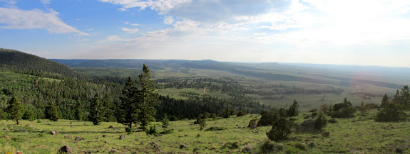
The view east from Boulder Mountain is unparallelled. You can get a good taste of it from Highway 12 on the eastern flank of Boulder Mountain, but that’s 1,500 to 2,000 feet below where we stood. From Bown’s Point we could see Capitol Reef and the Henry Mountains and beyond. Almost every color imaginable is visible in the vegetation and geology for as far as one can see. To get a better view to the north we hiked the Great Western Trail for a short distance.
It took some backtracking to the northwest until we hit another road leading east to Chokecherry (Tantalus) Point. It rained for much of that part of the ride, and I think the thunder had at least a few of us worried. The rain eased as we stopped for another hike along the Rim Trail to Chokecherry Point. At the point was a visitor register in a tea tin, but historically there was a different register that was visited by explorers, hunters, sheep and cattle herders, and other pioneers. The view from Chokecherry Point was much the same as from Bown’s Point, except one could see farther north from Chokecherry.
We took a more direct route back to our vehicles, with a quick stop to hike Bluebell Knoll, the highest point in Wayne County at 11,317′ in elevation. It turned out to be my 10th county high point in Utah–only 19 left to go! The mosquitoes were at their worst on Bluebell Knoll, and I’m glad it was late enough in the day that nobody wanted to spend much time there. 🙂 It was an easy gravel road from there back to our vehicles, but we’d seen a huge variety of road conditions during the day. From gravel, dirt, mud, snow, and rocks, we’d seen just about everything except sand and ice. My previous motorcycle experience hadn’t prepared me at all for this trip. At the beginning I felt uneasy and always on the edge of control, but by the end of the trip I was cruising easily and feeling completely comfortable on the rough, rocky roads.
Photo Gallery: Boulder Mountain
GPS Track and Photo Waypoints:
[Google Earth KMZ] [Gmap4 Satellite] [Gmap4 Topo]
