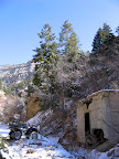
 The lousy weather we’ve been having lately finally let up today, so I went for a ride on my four-wheeler near Kenilworth. It was basically the same ride I’d done with my family last May, though this time I had been studying the area in Google Earth and had found some other interesting things to check out. The first place I went was Bull Hollow. The last time I was there, a boulder that had fallen and landed in the middle of the trail stopped us from going any farther on our ATVs. This time I had a shovel, and I spent about 10 minutes leveling the trail out so the boulder could be negotiated without scraping my fenders on it. From the end of the trail in Bull Hollow, I hiked up a very steep and rocky slope to see an old wooden water tank. It’s not visible from the trail in the bottom of the canyon, and it was barely visible in Google Earth. I doubt that many people have been up there in recent years, or even know it’s even there. On my way up the mountainside to the water tank, I stumbled across a very scary old mine portal that had long ago been buried, but the fill dirt is starting to slide downhill and now there’s a 10-15′ drop straight down into the mine tunnel. Torrey almost fell in it, and if she had I don’t think I could have ever gotten her out. When I got to the water tank, I was surprised to only find the wooden base–all the vertical slats were gone, as were the metal bands that once held it together. Strangely, there was no trail or road leading up there, and no sign that anybody had ever brought so many materials up or down the mountain. On my way back down the road in Bull Hollow I had planned on hiking/scrambling up a huge overburden pile to another mine, but the slope was covered in snow and I decided to skip it for today and try again later in the year.
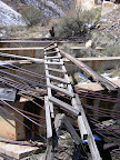
 Next, I rode across the Clay Banks to Cordingly Canyon. Near where the road forks in that canyon, in Google Earth I’d spotted what looked like a concrete foundation near the Milburn/Arronco mine. I scrambled up several sandstone ledges to get there, and found that it was indeed a concrete foundation, though it once supported another water tank. This one was missing most of its wooden base and vertical slats, but the metal bands were still there. The shape of the concrete foundation helped me identify this structure that I’d seen in Bull Hollow last year. After looking the area over and almost placing a geocache there (I changed my mind after not being able to find a good hiding spot), I rode farther up the left fork of Cordingly Canyon. The snow at the end of the road was still several feet deep, so I wasn’t able to hike around like I’d hoped to, so I ate a late lunch there, then rode back to the truck and headed home.