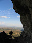
 Long story short, the “airplane” I thought I saw in the aerial photo turned out to be a big boulder. Mark and Chris and I parked below the mountain and scanned the mountainside but couldn’t make anything out, even with binoculars. However, it was obvious from there that the terrain was extremely rugged and it was entirely possible that there were areas we couldn’t see from the bottom, so we decided to start hiking up to where I thought the plane crash would be. It was slow going, but as long as we kept a slow pace it wasn’t too difficult. As my GPS showed that we were getting closer and closer to the coordinates, the anticipation kept building. Along the way I saw several footprints that indicated other hikers had been up there, which I took to be a good sign–after all, why else would somebody hike up that mountainside? When we were about 70 feet away, we rounded a corner along the cliff face that we’d been following and Mark and I spotted a large boulder that was lighter in color than the rest of the surrounding rocks, and we immediately suspected that we’d hiked all that way for nothing. We scrambled up a couple of ledges in the cliff face and the GPS zeroed out right on top of the boulder. A quick scan of the area revealed nothing but boulders, cliffs, and trees. I was bummed, but I knew there was a chance that this would happen.
We spent some time there just enjoying the view and resting. I contemplated placing a geocache there, but I wouldn’t wish that hike on anybody unless there was something rewarding at the end. I decided it would be nice to take a different route back just for a change of scenery, and that turned out to be a big mistake. The hike back to the car ended up being just as difficult as the hike up the mountain. We ended up above a line of cliffs that extended a quarter-mile around to the north side of the mountain, which, in that steep and rugged terrain, felt like two miles. We finally reached a place where the cliffs pinched out and we were able to slip and slide our way down the steep and loose mountainside until we reached the floor of the canyon below.
I don’t think I’ll be going on any more hikes looking for downed aircraft without more solid information. However, I was so close to summiting the top of that mountain–it would have been an easy 0.35 mile walk to the summit–that I may return just to experience the view from the top. I’m sure others have done the same on that mountain, but it would still be nice to be one of those very few.
So myth busted huh. Sorry you had to hike all the way up there for nothing oh well. I had heard that somebody salvaged some of it, but now I think it was all BS. Good view
from up there it looks like.
I dunno, I still think there’s an airplane up there. Both my mom and grandpa remember the sheriff’s department being up there for a couple of days while they recovered the bodies. My mom also recalls hearing that somebody salvaged the engine. I’ve been thinking about calling up the Carbon County airport and seeing if anybody there knows anything about it, and if they’ll divulge the location. If anybody knows about a plane crash, it would be somebody in the aviation community.
The view was awesome from up there, and the hike wasn’t too bad. I’ve decided that I want to go back just to summit that mountain, and then I’d like to summit the peak just northwest of Kenilworth. Since I can’t afford to fuel up my truck (or more specifically, I refuse to pay that much for fuel), I’ll be recreating more locally instead of in the San Rafael Swell where I’d normally be hanging out in my spare time. 🙂 The Kenilworth area has just seemed appealing this year, and so far it hasn’t let me down.
Darn, I was hoping you would find it.
Actually it was UFO and they were up there for a few days covering it up and taking the alien bodies and aircraft to the “new” Area 51 in Green River.